HOW TO SURVIVE A SOLO TREK THROUGH THE BOB MARSHALL WILDERNESS, MONTANA : PART 3
Mandy Mohler
Continued from PART 1 + PART 2
Satisfied by surviving my first day and night alone, I rose fairly early at the Pentagon Cabin, ready to face Day 2. This was supposed to be one of my most difficult days and I wanted to get an early start.
The hardest part of a hiking day is crawling out of the coziness of a warm sleeping bag, and committing to the brisk early morning. After fixing a quick breakfast of oatmeal and JetBoil coffee, I reluctantly traded my cozy fleece layers for hiking shorts and gaiters.
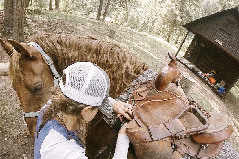
I then went about packing Ben for our adventure up and over Switchback Pass.


As soon as Ben was loaded and I confirmed that nothing had been left behind, I referenced my map and headed upstream towards Switchback Pass. On the trail, before we crossed over the river, the huckleberries were ripe and abundant. I indulged in a few, but passed up many patches to keep on schedule.
Despite warnings that the rivers were running high and potentially thigh deep, I encountered an easy ankle deep wade. I was excited that the first obstacle had been so easy. Knowing that I would then be climbing uphill over a mountain pass all day, I opted to keep my lightweight creek crossing trainers on. This was a good decision, because I ended up crossing several small streams throughout the day. I was able to save time on shoe swaps, while saving my heels from my stiff leather boots.
The day was hot and sunny. I continued to climb upward, curious of how long it would take me to reach the top of the pass. The pass proved to be quite an easy hike, and not nearly as difficult as I had anticipated.
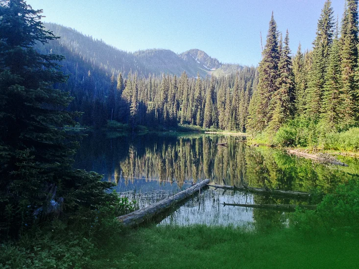
As I gained a higher elevation, I was able to glimpse a beautiful view from above the main tree line. Below is the beautiful Pendant Mountain.

When I reached the top of Switchback Pass I was able to see far into the distance in all directions. I was excited that the difficult part of the day was over. I just needed to head down the other side for a few miles to reach my destination of the beautiful turquoise Lake Levale.
While still at the top of the pass I took a moment to take some pictures, and also made an effort to call Josh on my phone. If there was one place I might potentially be able to get service, it was here. No such luck.


The top of the pass was quite rocky, and the trail became a bit less obvious. The most developed route went over the other side, and looked like it was heading around a rock formation to the right- which would lead me South down towards the Chinese Wall and to Lake Levale.
After reviewing my map and confirming that I was on the right path, I headed out and down the trail. It started to descend pretty quickly. Within a few minutes, despite my previous beliefs, the trail was no longer heading to the right - it was veering left. Still I hiked a little further- perhaps it would make a turn back to the right that I just couldn't see.
NO. It did not. The trail continued towards the North.
Immediately I felt a tingling of suspicion. I THINK WE ARE GOING THE WRONG WAY.
Frustrated, I dug into my top lid and pulled out my map again. Upon closer inspection, I noticed that we missed a vague trail up at the top of the pass. We were indeed going over the other side, but heading North towards Dean Lake.
Angry that I had just hiked down the wrong side of a mountain pass for 15 minutes or so, I spun around and hastily climbed back up to the top. I took deep lunging strides, and cut several corners, heading STRAIGHT UP.
Arriving back at the top, I took a few minutes to reevaluate the terrain. There was indeed a VERY VAGUE trail that I missed that followed the ridge line South down the pass, not going down the other side.
OK. Back on track. Heading in the right direction. I wasted a little time, but noticed my error and recovered quickly.
I hiked along the ridgeline for about 30 minutes or so until I reached the obvious downhill trail towards Lake Levale. Unfortunately, this correct trail did not contain any real switchbacks- and went straight down a fairly steep scree field that leveled out at the bottom. Once again, if I were hiking without Ben, this wouldn't be a problem and I could scramble down without any difficulty. However, the pitch of the terrain and the loose sliding rock worried me. If Ben happened to lose his footing while trailing behind me, it was very likely that he would take me out.
As I started to carefully descend, I kept Ben on a long lead. I wanted to give him the opportunity to choose his own footing while putting myself in a position to the front and side of him- so if he fell, it hopefully wouldn't be directly on top of me.
The trail footing was quite loose, and rocks rolled out from under our feet quite easily. While making his way, Ben managed to dislodge a rock about the size of a large gourd. It tumbled down towards me- and despite my best efforts, it clipped me directly in the ankle and knocked me off my feet. I knew my ankle wasn't broken, but I was worried about potential swelling and bruising. (It was at this point that I regretted my decision to wear my creek crossing trainers).
Ben, being the fantastic horse that he is, stopped dead in his tracks when I lost my footing and fell to the ground. However, when I gathered myself and attempted to start back down the trail, he wouldn't budge. I tugged at his lead rope and looked back at him to encourage him to walk on. He wouldn't. Trying to figure out what was wrong with him- I studied his face. He was making the most bizarre facial expression I have ever seen on a horse.
Right there in the steep scree field, I watched in horror as the 150 pounds of saddle and top packs slid over Ben's neck and head to land in a heap on the ground, tied around his two front legs. It happened quickly, but felt like slow motion at the same time. As the pack was slipping, all I could do was stare in disbelief and hope that I was hallucinating.
Amazingly, Ben didn't freak out or flinch. Rather, he had a look on his face that seemed to say: "Awesome. I'm not saddled anymore. I'll take it!" He stood there quietly as I rushed to unclip all the buckles and straps from around his legs.
DAMNIT. Here I was again... late in the afternoon, faced with an epic to deal with. No time to waste, let's get on with it.... As I walked naked Ben away from the gear pile, I thought to myself "I should have listened to June and put a crouper on the saddle....too late now."
Once I got down the hill to a relatively flat spot- I quickly realized I would need to short tie Ben to a boulder- there were no sturdy trees available. So I looped his lead rope around a substantial enough rock that was big enough not to be drug away- and small enough to get the lead rope around. I then placed my personal pack on top of the lead rope, hoping that would discourage Ben from simply walking forward and setting himself free.
I hiked back up the hillside and began to dismantle the packs and saddle. There was no way I was going to carry 150 lbs of well packed gear down the hillside- let alone this tangled mess of top packs, saddle, blankets and straps.
One by one, I carried loads of gear down to where I had tied Ben and placed them in an organized pile to be repacked.
As I brought down my last load and set it on the pile, I looked over at Ben and realized that he was close to freeing himself. He had lifted the boulder with his head, knocked off my pack, then stepped on it.
I immediately investigated my pack to make sure nothing had been seriously damaged. Within seconds I saw that he had stepped on my brand new Hydroflask and bent it severely. At first glance, I assumed it was ruined. Upon closer inspection, the outer wall on one side was collapsed- but the inside was barely affected. I still had plenty of water capacity. And actually- the new ding makes for a pretty nice handle....
As I moved through my pack, I noticed that Ben had ALSO stepped on my can of Bear Spray! The entire can was badly banged up and dented. OH. MY. STARS. The fact that the can didn't explode under the pressure of his foot is a Christmas Miracle. If it had exploded, chances are that Ben would have freaked out and bolted (hopefully not off the cliff that was about 100 feet away)...perhaps never to be seen again. And there I'd be, on the East side of Switchback Pass... maybe 30 miles past the Spotted Bear Ranger Station, with 180 pounds of gear soaked in pepper spray. At least I had my SPOT Beacon... and the canister hadn't exploded.
Luckily, Ben managed NOT to step on the loaded pistol that sat next to my Bear Spray in my pack's hip belt. If there is a lesson to be learned from this- it's that all valuable items need to be placed outside a 20 foot bubble of Ben.
As I sighed a sigh that was a mixture of frustration and relief (imagine that sound that your mom makes when she's had enough of your crap), I began re-saddling Ben. Once he was all loaded up- I looked around and realized that I was essentially in the middle of a scree field- with a steep cliffy region to the East and more scree field to the South. The trail was essentially non-existent. The only thing I knew was that I was supposed to be heading in the general direction of South and down. What I didn't know was whether or not I would be able to find the trail again, and if I was destined to encounter another hairy steep section.
I decided to meander through the scree field quickly but carefully- looking around for signs of traffic, a trail, or cairns. I eventually found a vague trail and followed it. The trail was simply a rock path in the middle of a rock field- and easy to lose.
As I progressed, I felt a twinge in my gut...we were getting closer to the edge of the "steep-as-heck" section, and I was worried about enduring another epic. I stopped, took out my map and evaluated the terrain lines. I was going the correct direction, however we were about to descend, and it appeared as if the elevation lines were quite close together. Not a good sign.
Because I didn't have a crouper (a butt strap that attaches to the saddle on one end, and wraps around the horse's tail on the other end- to prevent packs from sliding)- and I didn't want to repack Ben again that day, I knew I would need to improvise.
I looked over the packs and decided that the extreme top pack was only carrying the lightest gear (sleeping bag, pads, etc), and was the least likely to shift in a steep decent. It was held in place with 4 cordura straps with buckles. I knew that one strap wouldn't be long enough to catch the saddle, go all the way around the back of Ben's legs, and attach on the other side. However, if I removed two straps, I could link them together with one of the buckles, attach them to the saddle and tighten the tension enough to keep the whole opperation from slipping over his head again. The finished product wasn't pretty, and I doubt it was comfortable, but it eased my mind by adding a little stability to our system.
The sun was starting to get a little lower in the sky, and our day was about to get shorter as we descended further down the East side into the shadows. We slowly picked our way down the rock bands, and successfully navigated through the steep Switchback Pass.
About halfway down, I realized that while creating a butt strap for Ben, I forgot my tan leather gloves in the rocky scree section up the mountain. Oh well. There was NO WAY I was about to hike back up Switchback Pass to search for my gloves. Even if my hands were bleeding when I made it to Augusta... it just wasn't worth it. Hopefully someone finds them and gets use from them.
It was a great relief when we reached a DIRT path and a little shovel shaped sign marking the Continental Divide Trail. EUREKA. We only had a bit further to hike until we made it to our camp spot and the gorgeous Lake Levale.
Finding Lake Levale wasn't as obvious as I had anticipated. When looking at Google Maps and hiker photos of the lake in my preparation months, I envisioned a big grassy field that gently rolled down to the edge of the lake, which was clearly surrounded by the North section of the Chinese Wall. Ha, no. I couldn't have been further from the truth. In fact- unless you know its there, and you are LOOKING for it- you could completely MISS Lake Levale altogether.
The only giveaway we had, was the bare ground where a party had camped previously. The trail began to take off in multiple different directions like cow-paths. This was from packers letting their string of horses graze freely.
I looked around a bit, and assumed that the lake would be just up the hill from the camp site. I was correct. When reaching it, I was pleased to see that it was indeed as beautiful as I had imagined. However, there was no feasible place to camp where you could actually gaze on the beautiful lake. Lake Levale was much smaller than I anticipated, and essentially a glacial crater formed just below the rock bands of the Chinese Wall. There were steep banks surrounding it on all sides, and it was difficult for me to even walk along the shore line.

Still, I was delighted that there was some daylight left- I had my heart set on capturing a beautiful landscape shot, and more importantly a stop action sequence of sundown over the lake. While Ben was tied to a tree behind me, I went about setting up a tripod that I hoped wouldn't get knocked into the lake by some meandering wildlife. It was risky, but the terrain forced me to set up the tripod almost IN the lake. I set the camera to capture frames intermittently until dark.
While the camera was up there clicking away, I happily hiked back down the hill to set up a high line for Ben. Everything went smoothly, and I was able to set up a nice little camp right next to him. I spent the evening gathering firewood and preparing dinner. There was a pesky deer that found us and repeatedly attempted to steal pellets from Ben's feed sack. I literally had to throw rocks and pine cones at the beast to deter it.
I made the decision to consume and hang my food across the nearby stream, away from camp. I sat in the darkness with my headlamp eating JetBoil stew and could hear Ben nickering at me in the distance.
Below is the stop action footage I captured of sundown and the next mornings sunrise:
To be continued.... PART 4 : UNEXPECTED VISITORS
If you would like to receive notifications about future BOB BLOGS, please subscribe below.